Do you struggle with finding productive fishing spots offshore?
Do you want to catch big red snapper, gag grouper, scamp grouper and more – but you want to avoid driving your boat around aimlessly, burning fuel?
The Smart Fishing Spots App Helps You Find Productive Offshore Fishing Spots
 Join the Insider Club and get the Best All-In-One Fishing App for FREE
Sure, you can go on Youtube right now and see how to read your bottom sounder, how to see relief ledges, how to tell the difference between live bottom, sand and more.
All of that stuff is good to know.
But where do you start with a pre-trip plan? How do you know if you’re going to a productive spot in the first place?
It’s a big ocean – you can get lost pretty quick. It’s just a giant blue desert out there.
Not fishing the right spot means wasting a lot of time, and wasting a lot of money on gas.
So what I’m going to show you here today is a software developed at Salt Strong that’s helping me find NEW bottom-fishing spots.
This new app makes finding hidden honey holes for big snapper and grouper EASY!
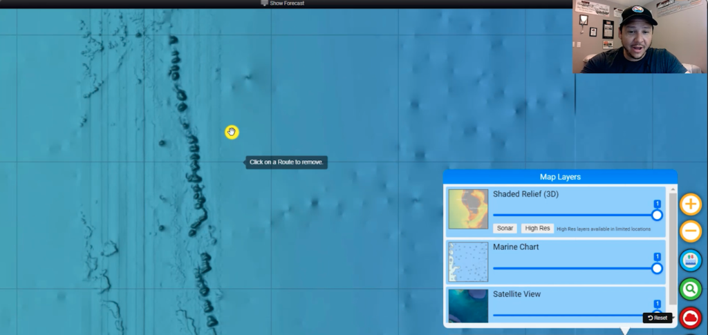
Satellite View – this works well to find spots for inshore fishing. But for offshore fishing, it can be deceiving. What looks like a good spot could actually be 1000 feet or deeper!
Marine Charts – to effective bottom fish for grouper or snapper, ideally I would be in that 90-300 foot range.
Routes & Tracks – use this to easily determine how far away a spot is from shore in nautical miles, as well as the exact latitude and longitude.
Shaded Relief (3D) – This is game-changing technology actually lets you SEE underwater structure: ledges, rocks, shipwrecks, reefs and more! This is where you’re most likely going to find gag grouper, scamp grouper and red snapper. Other apps and chart plotters might have some structure listed, like publicly recorded shipwrecks or “fish obstructions”, but none of them offer the level of detail of this Shaded Relief feature! Even worse, as a result, those spots will be over-fished by other anglers.
The best part about the Smart Fishing Spots app? It’s FREE for Insider members to use!

how does the relief shading feature compare to Navionics and Strike lines product for offshore Tampa Bay area?
Each program/App has a little different layer of information from one another. I find new contour & bottom on both the Smart Fishing Spots app as well as Navionics+ on my phone. I haven’t personally tried Strike Lines before, but I’m sure there are features that are revealed there that aren’t on the other 2.
I think it’s important to have a healthy variety of programs to use when it comes to scouting for new bottom areas to fish. So far, Smart Fishing Spots and Navionics+ has been all that I’ve needed to be productive just about everywhere Offshore in Florida.
How do you know if the tiles have been loaded for certain areas I’m not seeing any detail out of Crystal River?
Hey Ramon, I just checked out of Crystal River this morning and was able to find some excellent contour & shaded relief only 12 miles out. It certainly looks like a great spot to explore for Gag Grouper during the Fall & Winter Months when they move in shallower.
How can I get the App on my phone?
You can access this App on your phone by visiting our Community platform, use the drop down menu on the right hand side, and you can access Smart Fishing Spots from that location. Afterwards you should be able to save that location to your phone: Smart Fishing Spots (saltstrong.com)
Thats great Justin. Will take your advice an spend some time with the charts now that you make it look so easy. Tight Lines
For sure man! We are uploading more tiles everyday, so more information will pop up each time.
Hey Justin, the app is super great. But how about those fish at the beginning. Aren’t those slow pitch jig lures. When are you guys – Joe, Luke, Justin, … going to do a mini- or full course on slow pitch jigging?
Haha, Thank you man! I think it wouldn’t hurt to shoot them an email and ask for it! I’d be happy to talk about the Technique.
Justin,
Nice real world use/review on the SmartFishing app!
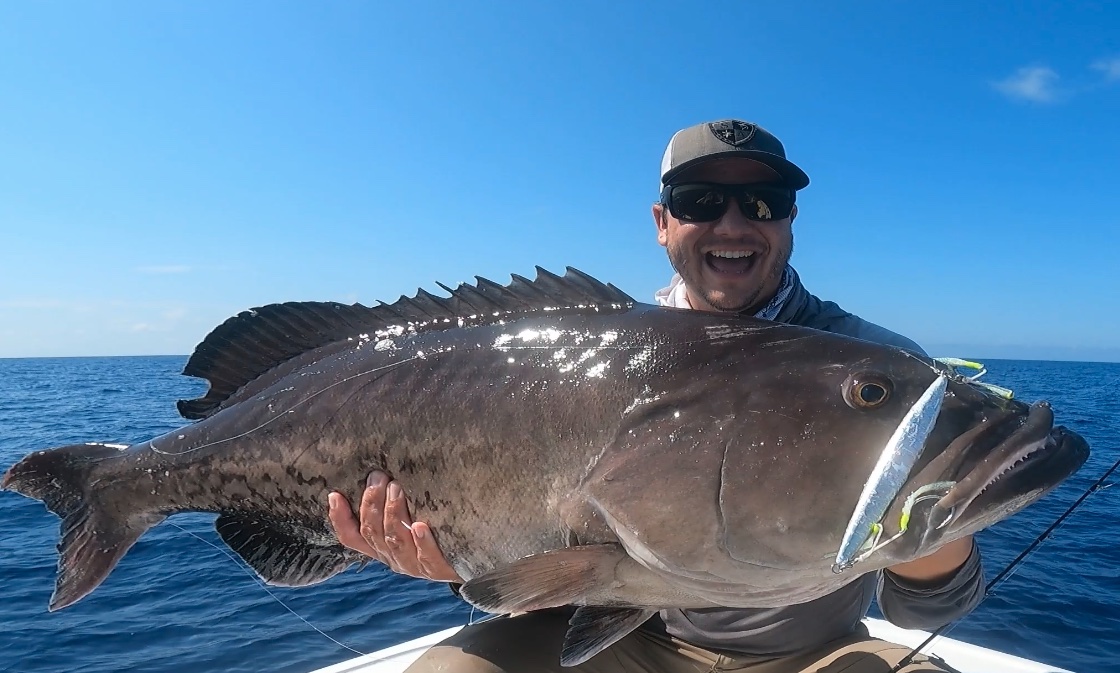
But, DUDE! That Big A** Grin of yours with that Awesome Gag Grouper was priceless! Congrats!
Haha, Thank you my man!
Sounds great, but where exactly do I find the app?
You can access the Smart Fishing Spots tool through our Community Platform. Here is a quick link: Smart Fishing Spots (saltstrong.com)
Great stuff Justin. To get to 60-100 feet on the gulf, as you know is 60 miles out! With gas prices those inshore spots look better and better every day!
I feel ya there! I’ve made that run many times out of Boca Grande to catch Red Snapper and Red Grouper. It’s pricey, but nothing can compare to hooking up with a big 20lb. Red Snapper!
Awesome job explaining it. Glad to see some offshore coverage. Hope too see coverage in this detail off the coast of SC soon.
Thank you Dennis! More Offshore Content coming soon (I’ll be heading out there more frequently over the Summer Months).
What am I missing here? This app is not that great. Maybe good inshore, but not so much offshore. There are very limited Hi Res areas in the Keys and specifically off Islamorda. Navionics has far better overlays for Relief Shading and Sonar Imagery. Also, how do you type in coordinates? I have areas that I want to look at. Maybe I am doing it wrong but at this moment, not impressed…
Ron,
I can’t speak for the Keys (as I have not explored that section in detail personally just yet), but please understand that imagery/tiles are being loaded into this program Daily, so the details will improve with each passing day. There are A LOT of Tiles to load, and it takes a great deal of time.
I’ll check with our IT Guy (Nick) to see how the interface is with typing coordinates. I’d definitely ask this question in our Community Page, you’ll get a super quick response there from him & other Team Members that might know.
Justin, thank you. I appreciate the response and info. I thought the program was full up and ready. I now understand it is still work progress. No issues with that. Also, thanks for checking on coordinates typing. That will be very helpful. Again, thanks for taking the time.
I can attest to new tiles being loaded frequently. I check the Ft. Pierce area frequently and there’s been new layers added each week (can zoom in more with the shaded relief). Be patient!
Thanks, Chase. Will do… I look forward to seeing some added down in the S. Florida and the Keys… Cheers.