Whether you’re fishing out of Venice, Hopedale, Delacroix, Grand Isle, or the endless marshes of the Louisiana coast, this place is HUGE. And figuring out where the fish are feeding on any given day can feel overwhelming.
In an area this large, you need a way to quickly eliminate dead zones and FIND THE FEEDING FISH. Otherwise, you’ll waste precious fishing days (and lots of gas money) wandering aimlessly.
What makes it even more difficult is that FISH MOVE A LOT. Even in the course of a single day, they can be in ENTIRELY different spots. Which means the old school “spot maps” are not going to help you, and probably just leave you frustrated. It’d be like trusting a broken clock, yes, it might be right twice a day, but that’s it.
Instead, you need to find fish based on their BIOLOGY and TRENDS. A great angler can calculate where feeding fish will be stacked up based on the tide, wind, temperature, season, moon phase, and water clarity, just to name a few factors… This is why it can take some anglers 30 years to master.
If you don’t have 30 years or can’t be on the water every single day to follow the fish around, there is a solution.
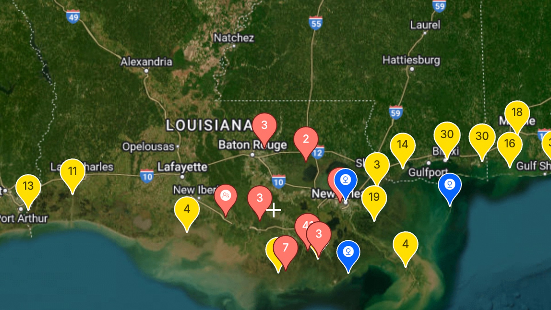
The video below will demonstrate how you can take a massive section of the Louisiana coastline, and INSTANTLY identify the best spots to fish FOR ANY GIVEN TIME. Please watch below. This method is already being employed by thousands of Anglers in your area and it can help you too.
👉 Learn how to get the Smart Fishing Spots tool here
3 Steps to Find Feeding Redfish in Louisiana Fast
There is a proven formula for finding feeding fish that the best Louisiana anglers can recite in their sleep. The formula itself is actually quite simple; that’s the beauty. But the steps to implement it can be incredibly time-consuming without the right tools (that’s why we showed you the video above, please watch it!). Most anglers fail because they only know a couple of pieces to this formula, OR they don’t have the information they need to execute it. We’re going to cover both for you right now.
Step 1. Find Structure
Structure attracts fish. Bait congregates around it for protection, and big fish use it for an ambush. But just one piece of structure by itself doesn’t make it a good spot. Not all structure is created equal… The BEST SPOTS will have multiple forms of structure to maximize your success.
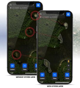
- Oyster Beds & Shell Bottom: Start your search with oyster beds—these are absolute fish magnets along the Louisiana coast, especially in areas like Barataria Bay, Breton Sound, and the marshes of Plaquemines Parish. These reefs offer ambush points for predators and attract all kinds of life. Using the Smart Fishing Spots App, you can see oyster beds and shell bottom with the click of a button.
- Marsh Edges: Louisiana’s marshes are some of the most productive in the world. Redfish cruise these edges looking for shrimp, mullet, and crabs. Focus on clean edges, drains, and points where bait naturally funnels through.
- Louisiana Shoreline Features: With so much winding shoreline, bayous, and canals, it’s key to look for areas where features like points, drains, islands, and manmade structures (like weirs and rock piles) create current breaks. These are classic ambush zones for feeding reds.
When you find multiple types of structure converging—like oyster beds near a drain, or a marsh point with nearby shell bottom—you’re in business.
Step 2. Find Depth Changes
Multiple Depths Hold More Fish:
Once you’ve found spots with multiple structures (like oyster beds, drains, and marsh edges), the next key is to check for nearby depth changes.
In Louisiana, some of the best fishing zones feature shallow ponds and flats adjacent to deeper bayous, dead-end canals, and pipeline cuts. Redfish and trout use these depth changes to move in and out with the tides.
Even a 1-2 foot drop can make a big difference. These depth changes provide security and easy access to feeding grounds.
Using the Smart Fishing Spots App’s 1ft Contour Lines Layer, you can easily see drop-offs, channels, and deeper pockets without wasting time and fuel.
Stacking structure with nearby depth changes is the foundation of this system.

Step 3. Fish at the Right Time
You’ve found the structure… you’ve identified the depth changes… Now it’s time to layer in the final piece of the puzzle: current and timing.
Current is what flips the feeding switch on. It pushes bait into ambush zones and helps predators conserve energy while food comes right to them.
In Louisiana waters, this is especially true around:
- Marsh drains and pond mouths
- Wind-driven points
- Cuts between islands and canals
Some areas fire best on an incoming tide, others on the outgoing. But one thing’s for sure—when the tide is moving, the bite usually is too.
With the Smart Fishing Spots App, you get real-time Louisiana tide and current overlays. You can instantly see which areas will have moving water and plan accordingly.
If you don’t want to stress over the details, the Strike Score indicator does the heavy lifting. It combines all the key factors—tide, wind, temp, pressure, moon phase—and gives you a simple readout for the best windows to fish.

GET THIS PROCESS DONE FOR YOU
Discover the Hottest Spots with a Single Click: If you can remember the formula above, you’ll have the basis to find good spots. But, if you want the GPS FAST-TRACK SHORTCUT right to the smartest spots in your area, then you should be using the Smart Fishing Spots App.
Whether you’re launching out of Delacroix, Hopedale, Venice, or Grand Isle, this app pulls in local knowledge, real-time data, and environmental factors to highlight when and where the bite will be best!
So even if you only get one trip a week, you can spend more time catching and less time guessing.
Planning a Saturday trip? Already on the water and not sure where to go? Just got skunked and need to pivot fast?
Pull up the app and click the Smart Spots Layer to see where to go.
This is the most powerful Inshore Fishing Tool software ever created.
Click Here to See All the Smart Spots in Your Area (and start catching more fish).
Salt Strong Fishing Club: Match the Tech With the Tackle and Teachings
The Smart Fishing Spots App is available to all Salt Strong Insiders. The Salt Strong Fishing Club is the largest, most helpful Inshore Fishing Club in America, focused on saving you time and money on the water, catching more fish, and connecting with other friendly anglers in your area.
With the Smart Fishing Spots App, proven custom tackle, real-time fishing trends, and an active Community, you get a GUARANTEED SYSTEM FOR CATCHING MORE FISH.
Learn more and try it out risk-free below.

We’d love to see you in the club!
Joe Simonds
Salt Strong Cofounder