Finding good fishing spots is one of the most important tasks for fishermen who want to consistently catch fish.
Because we aren’t able to find where our target fish are staging, we have no shot at catching them no matter how fancy our boat is, now smooth our reel is, or how great our bait is.

And on the contrary, if we simply find the feeding zones of our target fish, everything else is easier.
In past tutorials, we’ve covered how to efficiently find good fishing spots using online satellite imagery maps such as Google, Bing, and Mapquest.
But a limitation with those options is that they are only as good as the clarity of the satellite images.
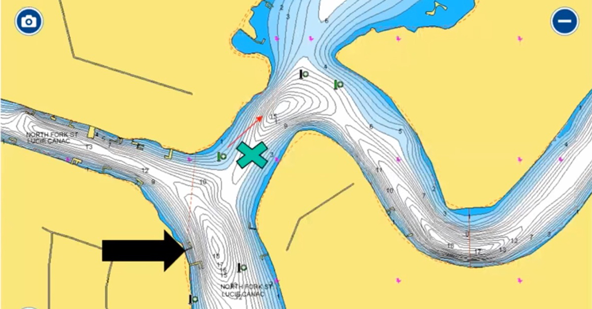
Fortunately, there is still a way to get some great insight into where the most probable feeding zones are in a given area… and that’s with the use of detailed maps that show the bottom contours.
And I am pleased to report that Paul Michele from Navionics was nice enough to get on a webinar with me to share some great tips on how you can use bottom contour data from mapping services like theirs to identify specific spots that are likely to hold feeding fish.
Click on the video image below to watch the webinar:
How To Use Navionics Contour Maps To Find Fishing Spots
Conclusion
Using maps to find new fishing spots doesn’t have to be just from satellite imagery.
As Paul explained in this webinar, there are some easy tactics for using bottom contour maps to quickly identify which areas are most likely to hold fish.
And just as importantly, which areas are most likely to be dead zones.
For more information about Navionics, click here.
And if you’re interested in learning about using satellite imagery maps, then check out the post below showing some examples from some of the most popular options.
Examples Of Free Satellite Imagery Maps For Finding New Inshore Fishing Spots
P.S. – If you think your angler friends or fishing networks would enjoy seeing this, please Tag them or Share this with them. You Rock! Pa-POW!
Fish On!

Thanks. This was helpful.
Sometimes all you need are a few interesting fishing spots for your next trip. One can select and download any spot from Navionics thru a small Chrome browser extension https://gomaps.ml. Then upload the GPX file to your GPS device and go get them!
pretty powerfull luke ! now can i load the information (if i knew how) from navionics app to my garmin73 dv ?
Garmin ????
Been using the app for couple of years now. With this and Google Earth I can preplan my trips. What makes the app nice is that I can add waypoints for the areas I want to fish so you can transfer that info to your GPS on the boat. Also what wasn’t mentions is you can add lat/lon for waypoints also which makes it convenient when someone gives you a new spot. You can again precheck it out before you go.
Great timing for this webinar. Finding holes is important right now and Navionics helps, especially, in the darker waters of Matlacha Pass.
Excellent information, I literally have goosebumps in anticipation of my next trip. I always knew about humps and tight lines being ledges but for some reason I never included the tide into the equation in a little deeper water. I do own the Southeast Navionics card for my machine and love it. But as with my phone, I have a ton of technology available to an old school thinker. Thanks to this excellent tutorial I just had many and most questions I had running around in my head answered. Thanks so much for taking the time Paul to share this invaluable Information with the Salt Strong tribe.
Awesome info, awesome webinar
Thanks for making time to leave the nice comment Joe!
When you head offshore, how can you plan for which direction the tide will moving in a particular spot? Or do you just need to go to the spot and determine onsite?
Can you give me information about fishing holes and areas to fish around Bonita Springs FL ?
Totally not understanding the difference on the maps between holes and lumps. I mean, some are obvious, but others I found myself not having a clue.