Fishing School
Understanding Tides & Currents
Of all the many variables that determine the feeding habits of redfish, snook, and trout, the most consistent and important variables for most regions is the moon’s orbit around the Earth.
This is because the gravitational pull from the moon is the primary factor that determines the tidal fluctuations of our waterways, which is the core driver of currents…
And the reason why we should focus on currents is because that is what most often triggers the prime feeding times given that many predator fish rely on current to bring food to them.
So the purpose of this post is to address 3 of the most important things to know about tides and currents so you’ll be better able to consistently put yourself in the right place at the right time for maximum fish catching…
1. What Drives Tides/Currents?
The gravitational pull of the Moon is by far the most significant driver of tides/currents…
Water responds to the Moon’s gravitational pull creating a bulge that follows the moon. And since Earth is constantly spinning, the side of Earth directly opposite from the moon has a bulge as well… aka – High Tide.
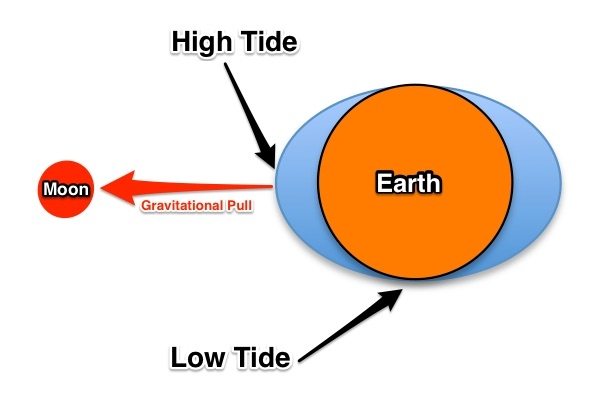
So this is why you’ll notice that it’s always a strong low tide in the evenings of both a Full and New moon phase because the moon is at its furthest point from being directly overhead or on the opposite side of your location on Earth at that point.
And since the Earth spins 360 degrees in a 24 hour period (while the moon only rotates around the Earth every 27.322 days), the parts of land directly touching the Oceans have two Highs and two Lows in a given day from the large bodies of water due to the bulge effect from the moon shown above.
For understanding day to day differences, it’s important to understand that the Earth must rotate an extra 12 degrees (which takes 50 minutes) for the moon to be directly over the same place as it was the day before since the Earth and Moon are moving in the same direction along their orbit with the Sun… this results in the tides arriving at the same location about 50 minutes later every day compared to the day prior.
Note: The gravitation pull of the Moon is by far the core driver of tides, but other factors such as wind, pressure changes, and recent rainfall can alter the normal tide and current levels/movements… see below.
Wind Impact to Tides/Currents
Wind plays a stronger role in tides than I used to think. Because wind on water causes friction that moves the top layer of water with it… this is hardly noticeable on small bodies of water, but constant wind on a huge body of water like the Atlantic or Gulf will shift water to the point where the water levels will be impacted.
For example, a constant wind of 10+ mph or more coming from the Northeast that we often get in FL will cause the water level along the Gulf coast of FL to be significantly lower than if no wind was present… making outgoing currents stronger and last longer.
And when that NE wind finally slows down, the water levels get back to normal after a strong incoming current brings water back in (and the opposite occurs if the wind comes from the West).
Air Pressure Impact to Tides/Currents
Air pressure can play impact normal tide levels too… a low pressure system will cause the water level to go up while a high pressure system pushes the water level down.
Example: Hurricanes are very large low pressure systems and one of their most dangerous aspects to coastal communities is the tidal surge that it creates (especially the side where the wind is blowing towards the shore).
And another example of this is seen in the ultra low water levels that our FL Gulf coast has after winter cold fronts (which are high pressure systems) come through bringing their strong winds from the North East… both the pressure and the wind combines to push water out of the inland waterways.
Recent Rainfall Impact to Tides/Currents
After periods of intense rain, the coastal waterways often have higher levels due to all of the water from inland draining out towards the Ocean/Gulf… this is less and less noticeable as you go from inland creeks out towards the Ocean/Gulf.
2. Difference Between Tide and Current
Many people believe that tides and currents are the same thing, when the truth is that they are very different… here are their official definitions:
- Tide: The regular upward and downward movement of the level of the ocean that is caused by the pull of the sun and the Moon on the Earth
- Current: The continuous movement of water in the same direction
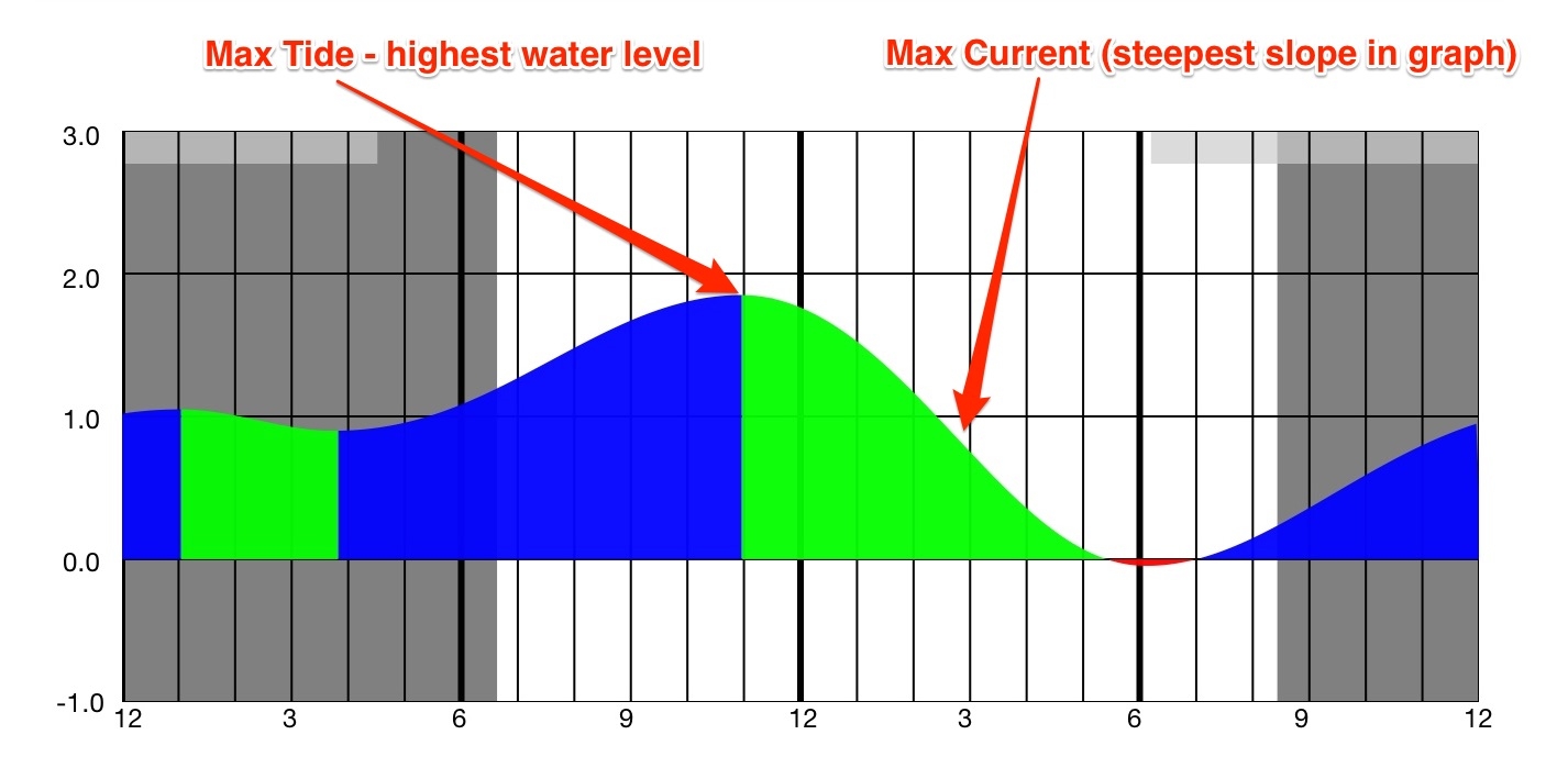
So Tide is the measure of vertical movement of water…
And Current is the measure of the horizontal movement of water.
The tide graph below shows how to determine both of them… current movement is at its peak slightly after the time where the tide levels change most quickly (as seen by the slope of a tide graph).
Tides – Quick Facts
Atlantic and Pacific Oceans have diurnal tides… two high tides and two low tides of similar heights every day
- This means that tides/currents from day to day are easy to predict because they are typically very similar in level… just delayed.
The Gulf of Mexico region has semi-diurnal tides… the tide peaks, valleys and durations are not consistent from day to day.
- This means that tides/currents from day to day are more difficult to predict because they fluctuate in heights and timing every day.
Tidal Movement Does Not Always Match Current Movement
I used to believe that an outgoing current always meant that the water level was going down (and visa versa)… but that is not always the case.
For instance, when a large inland body of water is fed by a relatively small inlet/pass, the change in current is always lagging the change of tide because it’s impossible for enough water to flow through the inlet/pass fast enough to keep up with the changing water level of the Ocean/Gulf…
The current is slack in an inlet/pass only when the water level of the two bodies of water it connects is equal… and this often occurs well after the official max or min tide levels of the Ocean/Gulf.
I personally learned this lesson when wade fishing a flat at the north-west end of Sebastian Inlet… which is a narrow inlet on the east coast of FL that connects the Atlantic (huge body of water that is directly impacted by the gravitational pulls of the moon/sun) to the Indian River, which is a good sized body of water (forming part of the massive Atlantic Intracoastal Waterway) that is only impacted by tidal fluctuations by the Atlantic via the water flow through Sebastian Inlet…
Normally, just being a narrow inlet or pass isn’t a big deal… however, in this instance there are no other inlets within ~20 miles north or south of this one so it’s literally the only place for water to move in and out.
So as the ocean level goes up due to the Earth’s gravitational pull from the Moon and Sun, the current is incredibly strong through Sebastian Inlet in an effort to get the water level of the very large Indian River system to keep up.
What I never thought of was the fact that there is a significant delay in the timing of max/min tidal levels in the river since it’s literally impossible for enough water to flow through the narrow inlet to lift the massive Atlantic Intracoastal Waterway system to the same highs/lows of the ocean…
Note: This is similar to a sand timer made of two larger areas with a small opening between the two for sand to pass through over an extended time before it fully moves from one side to the other.
How I Finally Realized The Current Delay
So it was a cold February morning and my plan was to fish a flat that required wading through a fairly shallow channel (depending on tide levels)…
When arriving, I saw that the current was going out so I assumed that my tide table was wrong and waded across the cut which was about thigh deep thinking that it would only get more shallow as the water moved out of the river into the ocean.
However, after a couple hours of fishing, that same cut was over waste deep so I had to get completely soaked in cold water to get back to my car…
And I was completely baffled as to how the water level rose while the current was going out the entire time.
Why Does This Matter?
Passes and inlets are often best to fish right before and after the current switches… the ~30 min before and after slack current is when I catch a vast majority of snook and redfish in passes/inlets.
So knowing that there is a lag time from the current change to the change of the tide can help you more effectively plan your trip so you’re in the right area at the right time.
How Long of a Delay Between the Turn of Tide vs. Current in Inlets/Passes?
Every inlet/pass is different… and wind, recent rainfall, and barometric pressure changes all impact the timing.
What is consistent is that the passes/inlets (like Sebastian Inlet) that connect the Ocean to a large body of inland water have the largest lag times between when the tide level changes and when the current changes…
And then a much wider inlet/pass (like Boca Grande) with others nearby allow for the lag time to be much smaller.
For example, the lag time at Sebastian is typically around 2.5 hours a tidal high/low. While Boca Grande’s lag time is often around an hour.
How to Determine The Best Time to Catch Fish
My overall recommendation is to fish whenever you can without fretting about the fish biting or not based on tides… because there’s always some to be caught on all phases of the tide/current so it’s best to simply just get out there.
But if you have only a limited amount of time to be able to fish and want to plan it around the “textbook” time to fish, then here are some things to consider…
Twilight Trumps Tides
The hour before and after the sun goes up and down will almost always trigger a good bite, so I like to try to plan my trips around one or the other any chance I get.
Ideally, I’d like to see some good current happening at twilight, but I’d still rather fish a bad tide at twilight than a good tide in the middle of the day.
Predator Fish Prefer Current
Predator fish often rely upon the current to bring their food to them… many shrimp, crabs, and small bait fish often flow with the current, so predator fish like snook, redfish, and trout often sit in a single spot and wait for food to come into the range of sight/smell/feel when in areas with strong current.
But too much current can be a bad thing as it’s tiring for fish to fight it and it’s difficult to fish quickly moving water due to the drag on the line…
So it’s best to target inlets/passes with fast water (defined simply as water that would be hard for you or I to swim against) at the turns of the tide…
And it’s best to target flats and mangrove lines during the peak current phase of the tides.
Conclusion
It is extremely important for an angler to have a solid understanding of the core drivers of tides and currents.
This knowledge will help ensure you don’t get surprised by fluctuating water levels so you can safely explore new areas…
And it also can significantly help you put yourself into the right place at the right time more frequently.
P.S. – This is a very important topic, so please do not hesitate to ask any questions in the comment field below.
It took my addled brain a bit to realize that we are looking at the moon/earth graphic from above with the earth rotating under our perspective, rather than from the side. Also fascinating is that the bulges are about the same.
I just finished the modules but perhaps I missed it in one of the lessons. How could I tell the current flow before getting on the water in a place like corpus christi bay. Where it can exit at the aransas or the packrey channel jetty. Would flowing the wind current be the best way to predict the flow?
Hey Eduardo, my apologies for missing your question about determining current flow direction. Here’s a helpful video that shows how to determine current flow direction while out on the water: https://www.saltstrong.com/articles/how-to-determine-current-direction/
I just finished going through all of the modules in the fishing school course. I will need to re-watch many of the videos again as there’s a ton of information to take in. Even having just watched the series once, I have learned more about fishing than I ever knew before. Absolutely great information. Worth the cost of the membership just in this series of videos. In addition to the basic membership, I also signed up for the VIP classes and have many hours of video to watch there. Glad I signed up. I will recommend Salt Strong to my friends who are interested in fishing.
Thanks for compiling all of this information into an easy to use package.
Glenn
Thanks so much for making time to post the nice comment Glenn! We are so glad to see that you enjoyed these lessons.
Incredibly informative session! I’ve been through the section multiple times and it answered questions I’ve had about things I noticed with tides and currents, but no one could answer. What a great source of information!
Great job Salt Strong!
Very informative class !! Thank you. I’ll have to go over it again a few more times to have it sink in.
now i’m getting the hang of it thanks Luke
Very good lesson How can we use the tidal coefficient as an indicator of tidal movement?
yeah that is a lot will take some time to figure all that out but thanks for the info
Wow this is a lot to take in, I’ll just have to read it a couple of times. Thanks Luke
Been fishing the west side of florida, pinellas county, for some 60+ years and never thought about any of the information you just presented. The old theory was to plan your fishing an hour before the high. Much more time reading this lesson to “get it”. Thanks Luke