How do you calculate the differences in the timing of tides in between tide stations on tide maps?
If you fish in areas close to tide stations but not close enough to rely on the tide readings, then how do you accurately predict the tides?

In reality, you aren’t going to be fishing where the tide stations are so it is an important skill for any angler to be able to determine the tides where you are fishing based on nearby tide stations.
Check out more below!!
How To Calculate Tides In Between Tide Stations [VIDEO]
 Click here to join the Insider Club
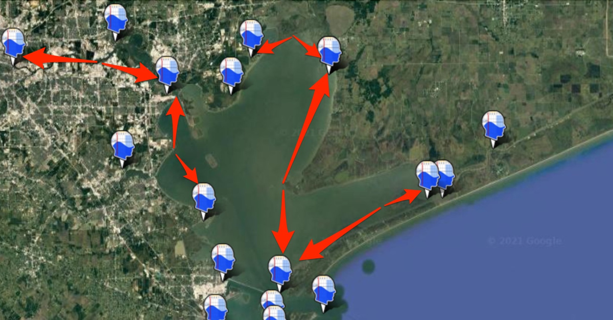
The premise discussed in this video holds true to any area, not just the ones shown in Florida and Texas.
Tides always begin out in the bigger bodies of water such as the Atlantic Ocean or in the Gulf of Mexico.
As the tide moves inland, it is delayed the further inland you are.
For example, when you inspect tides between two tide stations, the farther location from the larger body of incoming water will be a more delayed tide than the station closer to the larger body of water.
Tides that are further inland are delayed compared to tides closer to the ocean.
Using SmartTides, or however you obtain your tide information if you aren’t an insider member, you can pick two spots along where you intend to fish and subtract the difference between the low or high tide times to figure out the timing of tides in between the stations.
This is not a one size fits all demonstration as there are other factors at play.
The hydrodynamics of the water is in play as well as the impact of constriction zones that will cause a delay in tides.
Areas With Only One Nearby Tide Station
There may be scenarios where there aren’t two tide stations next to where you aim to go fishing.
If that is the case, follow the flow of the current.
Make sure you are following up current or down current from the tide station you are looking at.
Begin with a tide station next to where the water has to pass through to get to where you want to fish.
Then, select a tide station on the other side of where you are fishing.
The difference between these two stations will give you an idea of the tide in the area between them.
There is no way to uncover the perfect time of the tide.
However, this method will get it close enough to where you can judge the tide in an area between tide stations.
Tide stations aren’t perfect but they are accurate enough to predict tides.
The stations factor in the gravitational pull of the Earth, the moon, and the sun.
They do not factor in changes in wind and pressure that are important for tidal movement.
As a result, the difference in times of the tides you are looking for assumes there are not any changes in wind or pressure.
If you have any further questions on the timing of tides in bays or around chokepoints, please ask me down in the comments!
And if you know someone who wants to learn how to calculate tides in between tide stations, please TAG or SHARE this with them!
P.S. Want access to our best fishing spots and tips, plus discounts to our online tackle store? Click here to join us in the Insider Club!
Related Articles:


Do you know if the tide stations make their predictions based on zero wind and the projected barometric pressure and rainfall? How far in advance are the tide charts calculated/published?
I’ve been using this info daily since it was posted, however I’m still struggling a bit. I’m in the Oyster Creek/Bayou area just north of Gulf Harbors in New Port Richey. Using the tide calculations and strike scores have greatly improved my performance since I just recently moved to this property, and yet I can’t seem to get it down to a science. For example, I go outside when I know the tide/current should be at a certain point, and yet it’s not as of yet… then I try to do the math next time, and it’s like I missed the window instead. How much does being in the residential area on a canal make a difference if I’m only a couple of curves from the opening to gulf itself? On that note, do you simply set a timelapse or sit outside watching the waterline to be able to identify the peak high/low of the tides?
Nothing beats developing local knowledge. The stations are a big help but the topography has an impact on how the tide progresses in a particular area especially if there a lot of islands, back bays and channels. One can move a short distance where the tide is pretty slow or slacking to a constricted channel dumping from an area resulting in an increased flow.
In Vermilion Bay Louisiana we generally have little tidal movement compared to Florida and the East coast but we do have lots of wind. Is there a way to factor in how much the wind will affect small tidal changes?
Unfortunately not because the wind impact is most due to the layout of whichever body of water you’ll be fishing. But once you see the impact from a specific wind relative to a regular tide, that difference can be used for future trips.
In the Texas example in this tutorial would San Leon be similar if you were going to fish Smith Point being it is almost directly across the bay making the other side of the pinch point?
A spot on the other side of the bay should be very similar unless there are any big obstructions of water flow on one or the other sides. But I still would rather use two points in the direct flow of water to be on the safe side.
In places like New River inlet, NC, you get a tide station at the mouth and that is it. Nothing for many miles upriver. Perhaps SaltStrong anglers can get together and note the nearest tide station and the tide level in the creek or river area where they fished in the fishing report. Then others can compare that to the inlet gauge and help planning future trips. That is a way to harness the local knowledge of our group when no tide station exists.
Once the delay time for a particular spot from a known tide station is known, it typically holds true so make sure to take note of how the actual change for your favorite spots compares to the nearest tide station.
I fish there! Way up the Newport. We find that the Yacht club station is the closest. Rule of thumb is water changes direction about 2 hours after the time the Yacht club has listed. We are usually pretty close. Depends on if we are at Cross Rock or further up.
How does this work on Florida’s West Coast. For instance in my neck of the woods there is Aripeka, Hernando Beach and Bayport. All are shown as the same distance from the Gulf with HB being in the middle. Aripeka to the South has almost the same low tide time today as Bayport to the North yet HB was 45 minutes later than both. I understand when you are heading shoreward it takes longer but these are more of a North/South change. Can I still use the same mathematical principle?
Areas like Aripeka can be tough because there are a lot of waterways with few tide stations. It’s generally best to be very cautious your first few times out there and to take note of how the actual change compares to the nearest tide station… once that delay is known, it typically will hold true going forward.
With two or more inlets, separated by by several miles of barrier islands, the inshore tide calculation becomes much more difficult to predict without tide stations. We see this along Cape Lookout in North Carolina with several inlets scattered over thirty miles with some tides stations 30 miles apart. The water flow rate through the various inlets affect the in-between spots, but frankly the multiple variables make predicting tides extremely difficult. In these cases, local knowledge is most valuable and possibly the only way (in that I am yet to see any accurate published information) on this northern Core Sound to southern Pamlico Sound area.
Very true… areas like that with large inshore rivers/bays and few tide stations can get tricky. In zones like that with large bodies of inshore water with a lot of waterflow constriction to the Atlantic/Gulf, the wind changes can often swing the tides a significant amount.
Rider.
Do not rely on digital aids. Eire recently lost a Coastguard Chopper and crew.
Bloody great sea stack not even on the chart.
You guys have just had issue with a fish clouting a sea mount in the South China Seas.
MkI eyeball and sounding pole. Can’t beat it.
I agree that the tide charts should not be relied on too heavily since they only factor in the gravitational forces… other factors like wind, pressure, and rainfall can all impact what the actual tides are vs. what was predicted from the charts.
For a mere fraction of the cost of your fishing equipment, detailed tidal patterns will be available, in a gurt great Almanac for anywhere that matters.
You purchase annual updates to keep your tidal predictions up to date, plus any significant other issues. Think of it as tide tables, tidal patterns and a marine NOTAM binder all in one place. Invest in real charts. A gratifying hobby in it’s own right.
We have access to Admiralty Charts going back 500years.
Luke’s reference to winds and pressure is very moot.
You are unlikely to be out in strong offshore winds and low pressure but you could well loose several feet in a big high. Very dangerous if bars need to be crossed or you plan drifting over shallow structures.
Rgds.
In areas that are skinny like the Everglades, the winds have more impact on water levels than the tides. Wind can and often blow almost all of the water off a flat.
Very true… the wind can make a significant impact (Hurricanes are an extreme example)
What is a gurt great almanac? Can’t find anything in a search.