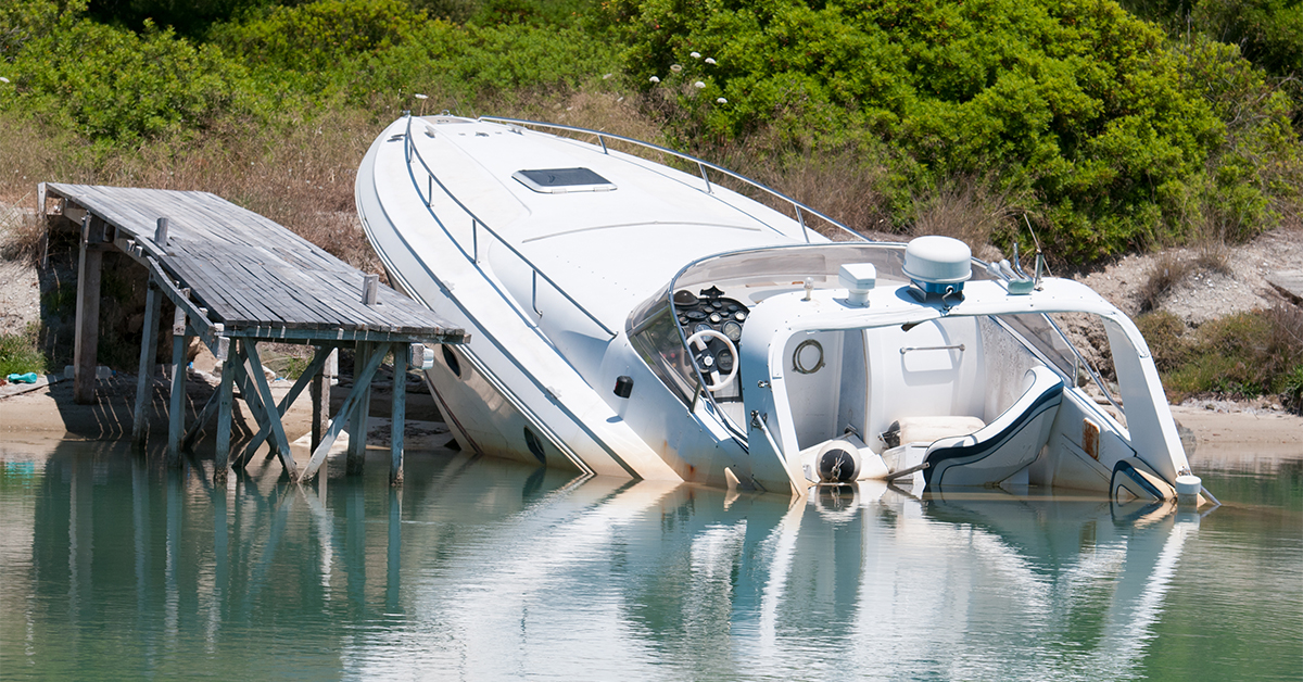
You never want this to happen to you…
Almost every time I drive my boat past this certain spot at low tide I see somebody pushing their boat off of the sandbar.
It’s a tough spot to navigate because there’s a shallow grass flat on one side and a sandbar on the other (with no channel markers to guide you).
But there is one little hack that I’ve learned that can help you avoid sandbars and grass flats and keep your boat from running aground.
You’re likely holding the tool to this hack in the palm of your hand right now, and if you watch the video below I’ll show you how it can save you from:
- potential injury
- outrageous boat repair costs
- decimating our grass flats.
Enjoy!
Disclaimer: storms and currents can change locations of flats and sandbars (especially if they don’t have seagrass, rocks, or anything else holding them in place), so be extra careful when using any maps for boat navigation since they can very well be incorrect.
Free App For Boat Navigation [VIDEO]
 Click here to join the Salt Strong Insider Club
Running aground can ruin your hull or your motor (and cost you big bucks), and if you run too shallow over grass flats it can leave prop scars, which can last for years and really damage the environment, not to mention that you could get injured if you suddenly run aground.
Using this free app can help you avoid all of that!
Free App For Boat Navigation
There are surely multiple free apps for boat navigation that you can use on your phone while out on the water. The key is to find one that has the following:
- Clear satellite imagery
- Current location mark
- Low data usage (so it can work away from wifi)
Here are some details for the one that I like best (comes free on all iPhones):
The app shown above is the one I was using in the video to show the general premise of using a free mapping app to safely navigate a boat.
Here are some details on exactly how to use it in case interested:
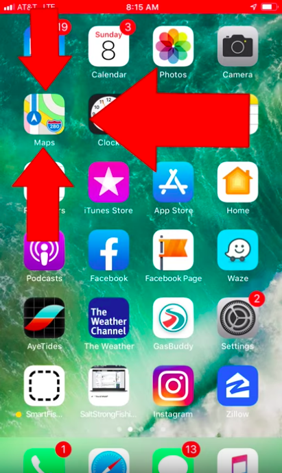
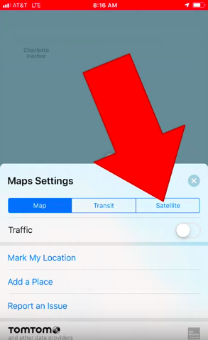
To change it from map view to satellite view, all you need to is tap the “i” icon in the top right corner…
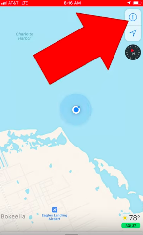
Then click the satellite button on the right…
Which will allow you to view the satellite version of the map with the blue dot that indicates your location.
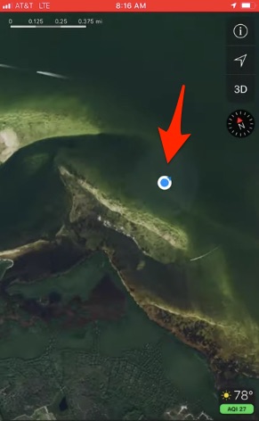
Now, all you need to do is make sure the blue dot doesn’t run aground on sand bars or grass flats!
Conclusion
The mapping technology has come a long way in the past 20 years, and that has given us fishermen a huge boost in being able to safely navigate our boats even in areas we’ve never been to before.
And the coolest thing is that now there are many free tools like the map shown in this post that enables us to get extremely helpful data without spending a dime.
Best if all, these new mapping tools can very well help us save our precious grass flats from getting any more prop scar marks in them if all boaters simply knew how to use them.
Have you used other free apps that can do this too? If so, please let us all know by leaving a Comment below.
And please TAG or SHARE this with a fellow boat owner so that we can all be more safe and friendly to our grass flats.
P.S. Want access to the best fishing spots, tips, and exclusive gear? Click here to join us and +9,000 other anglers in the Insider Club!
Do You Want To Quickly Find New Fishing Spots In Your Area?
Then you’ve got to see this private fishing club!
Here’s what you’ll receive today:
- Weekly fishing reports and TRENDS revealing where the inshore fish are feeding all year long
- Weekly “spot dissection” videos that walk you through all the best spots in certain areas
- Exclusive fishing tips from the PROS you can’t find anywhere else
- Everything you need to start catching fish more consistently (regardless if you fish out of a boat, kayak, or land).
Click here to join today.
Related articles:

I used to use the map app on my iPhone when I was working with Texas EquuSearch looking for lost souls. Now I see that it has a real plus when out on the boat that supplements/compliments my Garmin! Tips are good things!!
Thanks for making time to leave the nice comment Skipper!
Wow Thanks for the tip. Never knew that.
Thanks for making time to leave the comment Joyce!
Thanks for the tip. I always appreciate your contributions.
My pleasure Roger! Thanks so much for making time to leave the nice comment.
Thanks for a geat tip! I have an area I fish that has a long skinny oyster bar that runs across a cove. There’s one narrow cut through the bar to go through if you want to be on the other side. Started using my phone (zoomed in) last spring to make that transition. Works great.
Since I regularly use my phone in my boat I have a phone holder with a suction cup on the inside of the winshield of the center console so I can see it as I drive the boat. With the exception of harsh sunlight it’s positioned in a way (angle) that allows me a great handsfree view while driving the boat.
Bubba
Great idea about adding a phone mount to your center console!
Luke, thanks for a great tip, I’ll use it new time I am out – probably fishing Steinhatchee. BTW, what phone cover are you using that gives waterproof protection, an Otter or what? I normally stow my phone in a dry box and use my chartplotter because I don’t have satellite coverage. Thanks.
My pleasure Glenn! I use a basic cheap phone cover that is not waterproof because the phone I have (iPhone 7) is supposed to be water-resistant… I fortunately haven’t put it to the full test yet though.
If I go wade fishing, I’ll just put it in a ziplock bag to be on the safe side.
Great tips. Thanks. I would like the dissecting inshore fishing spots for the Homosassa and Crystal River areas. Also I tried ordering your free hard cope book on inshore fishing. I’m not sure it went through. Thanks, John White
There are some spot dissections along with a lot of fishing reports in the Homosassa and Crystal River areas that can be found from the Master Reports Map linked here: https://community.saltstrong.com/RegionalMap.php
As for your Manifesto order, I just checked our system and did not see an order under your name. Here’s a link where you can download a free PDF version of it: https://secure.saltstrong.com/manifesto
And after downloading, you’ll have the option to place an order for the hard copy that’s free but just requires the shipping costs for us to be able to send it out… if you did get a charge for shipping previously, please let me know.
I guess I must be different then most anglers I have never ran aground but I usually don’t go very fast especially if I don’t know the area very well if at all plus I’m always looking at my depth finder and if the bottom is coming up to fast I slow down to a crawl and also look for channel markers plus if you review an area on a satellite map it usually shows you the depth contours and if you know how to read water and know that dark water usually means deeper and lighter colored water especially if in an area next to dark water will tell you because it’s lighter in color that chances are good that it’s much shallower and one needs to go very slow if traveling through it plus here in northeast fl we don’t have seagrass or very little our bottoms here are mostly mud and not sand like in central or south fl????
Mr Free
I do the same ,slow is best for me when I dont know the area.
Rick
thank you Luke
My pleasure Tony! Thanks for leaving the nice comment.
That was a GREAT tip Luke, thank you !
Thanks Robert!
Thank you Luke
This was great!