#1 Hack For Finding New Fishing Spots in Dirty Water
- By: Wyatt Parcel
- on
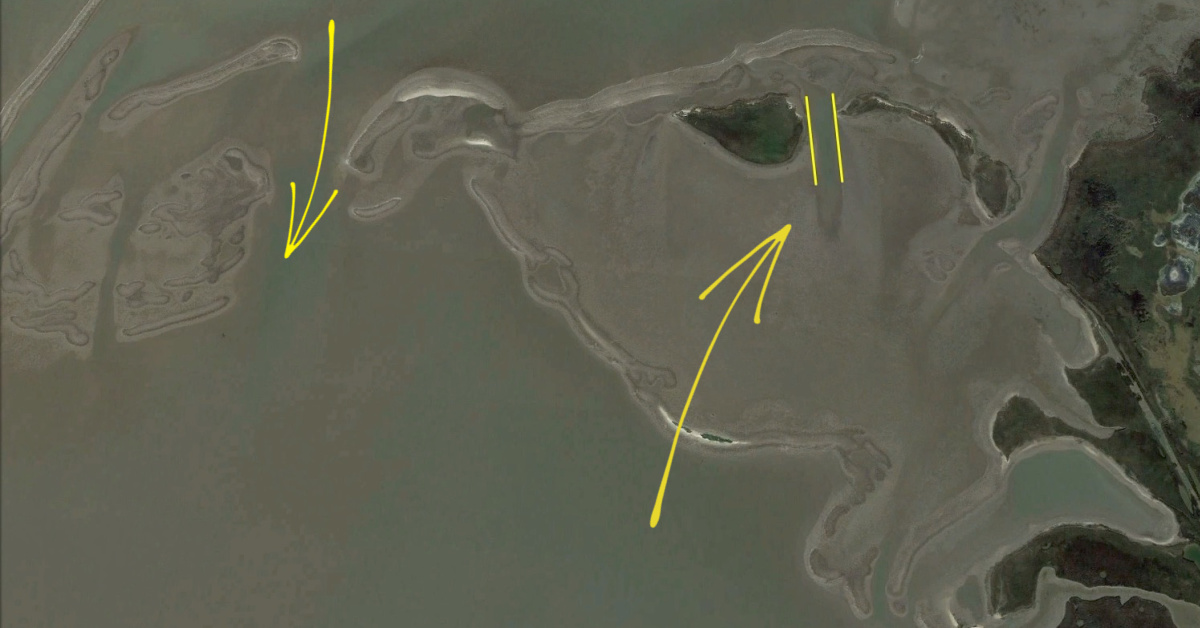
If you often fish in dirty water, how can you find new spots to fish in?
What should you be looking for?
Scouting for new spots in regions with dirty water can be an absolute pain, but with this nifty satellite imagery trick, you can find crystal clear pictures of the areas you’re fishing!
Check out more here!
#1 Hack For Finding New Fishing Spots in Dirty Water [VIDEO]

The first step is to open up Google Earth on your desktop and not your phone because there is a feature available to you only on desktop computers or laptops.
Google Earth on a computer has a Historical Imagery function at the top.
If you are scouting potential fishing spots in dirty water using Google Earth, the Historical Imagery function allows you to scroll back in time to find pockets and spots with clearer water.
Not every image will be clear and perfect, but they will give you a general idea of areas that were once cleaner.
It is best to view the historical data in the winter months because that is when the water is clearest.
In the summer, there is a lot of algae blooms and heavier winds that distort the images.
After you go back a few years looking at different spots, you can see oyster bars and cuts in-between land formations.
This is an extremely useful tool if you are fishing in Louisiana, Texas, Georgia, and the Carolinas.
These areas have lots of fishing spots with dirty water and you will learn more about them using this hack.
If you scroll back a few years on different fishing spots, you will start to pick up on different hues and structures you may not have seen in the current year or even knew were there.
One thing to make note of is that throughout the years, structure can change.
This is a good practice to instill into your fishing routine even if you do not fish in dirty water.
You can pick up on hues and structure you may not have been aware of.
Have any further questions on fishing spot selection?
Let me know down in the comments!
And if you know someone who wants to learn the #1 hack for finding fishing spots in dirty water, please TAG or SHARE this with them!
P.S. Want access to our best fishing spots and tips, plus discounts to our online tackle store? Click here to join us in the Insider Club!
Related Articles:
Related categories:
STOP WASTING TIME ON THE WATER!
Do what the “SMART ANGLERS” are doing and join the Insider Club.
Here’s what you’ll receive today when you join:
- Weekly fishing reports and TRENDS revealing exactly where you should fish every trip
- Weekly “spot dissection” videos that walk you through all the best spots in your area
- Exclusive fishing tips from the PROS you can’t find anywhere else
- Everything you need to start catching fish more consistently (regardless if you fish out of a boat, kayak, or land).




Excellent tip!
great tip Wyatt thank you. I also like to scout in person during winter months when the water clears up here in VA. Even in areas I am already familiar with you can find features in clear water that you can’t normally see when fishing in summer or fall.
Thank you Wyatt. Some of the older views are much more clear for our area near Homosassa, FL. I first tried Earth on my desktop using a browser and was not able to find the historical views button. Then I downloaded the Earth Pro App, and it was right where you showed it. Great tip.
That’s really cool Wyatt and crazy how you chose that Texas location as Christmas and Drum bay are my primary spots especially the reef with the two cuts highlighted. Any plans to fish this area while you’re in Corpus?
I’ve actually already fished this area! If you’d like to see the insider report, you can check it out here:
https://www.saltstrong.com/insiders/spring-tactics-for-redfish-pt-3-post-frontal-insider-report/
Wow you may be a young buck but you just taught this old 58 year old dog a new trick even though I live in Florida it’s the northeast region Jacksonville st Augustine to be exact and I remember when I first joined saltstrong then liked it and decided to be a life member in March of 18 I was always frustrated by the fact that the water here in northeast Florida the majority of the time is murky and I know you being from North Carolina originally then moving to Texas experienced the same thing I used to tell Luke about my frustration slot and really I never got any help until now thank you so much this will help tremendously also being an old you know what I’m not great at computers and know for a fact I probably would of never discovered this awesome tip on my own😊😉👍
Steven, I’m glad I was able to showcase this for you sir! Thanks so much for watching!
Thank you for sharing Wyatt! I fished that Christmas Bay area and caught a flounder in that cut you indicated (Arcadia Reef, 2 summers ago). It’s interesting that the historical data at low tide displays that the true nature of that cut while revealing that the “cut” to the right (east) is actually more of a depression/hole.
Absolutely Jonathan! I love that area and almost passed it up myself until I saw it using the historical imagery. Definitely a useful tool for finding good holes!
Awesome tip Wyatt ! Thank you sir.
No problem Stan! Thanks so much for watching sir!
This is a GREAT TIP, thanks Wyatt!
Definitely can be useful for those dirty water marshes! Thanks for watching Buddy!
Several times a year — not quite monthly but almost — I get something from SS and think, “THAT was worth my membership fee.”
This was one of those.
P.S. I don’t count how much I save on tackle because I KNOW I spend way more because of the discount…
Hey, that’s what we’re here for!! So glad this one was helpful for you Philip!
Hello Wyatt,
I have not seen those features on the Google Earth desktop application. Are you using a version that requires a subscription?
Rick,
You need to have Google Earth PRO to access that feature & others. It is still free, but it does take up more memory space. That stumped me for a while as well!
Thanks so much for the tip Neal. Yes, I’ve been puzzled about that and will go look for Google Earth PRO.
Thanks for that helpful tip, Neal.
No, as Neal mentioned, this is Google Earth Pro (which is also free). I actually didn’t know there was another version until just now, otherwise I’d have clarified in the video.