Here’s one of the biggest mistakes anglers make…
Not planning their trips out properly.
Sure, most anglers check the tides and weather, but there’s so much more to plan out (this is one of the biggest differences between the pros and weekend warriors).
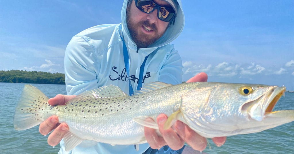
Tony, one of our Salt Strong Fishing Coaches, is one of the best fishermen I know.
He’s always catching monster fish and many people think he spends every day out on the water.
But here’s the funny thing: he lives in Orlando!
It’s an hour and a half to the water each way, so he spends a lot of time planning out his trips to make the most out of them.
And that’s a big reason why he’s so successful.
A few years ago, my family and I lived on the water in Tampa.
It was so convenient to go fishing (I just walked out to my backyard) that I never really bothered to plan out my trips that well.
Because of this, I barely caught any fish, even though I was spending a lot of time on the water.
Does that sound familiar?
In this video, Luke and I are going to walk through a case study of how to plan a trip so you can start catching more fish and maximizing your time on the water.
Whether you fish from a boat, kayak, or shore, this is one of the best things that you can do to step up your fishing game.
You can watch the video version of this podcast below (which I definitely recommend since Luke shares his computer screen and shows some good spots), listen to the audio version by clicking the play button underneath it, or listen to it on iTunes, Stitcher, or Spotify.
P.S. Don’t forget to subscribe on iTunes, Stitcher, or Spotify and leave us a review!
The Ultimate Pre-Trip Planning Blueprint [VIDEO]
 Click here to join the Insider Club
Mentioned sites:
The Ultimate Pre-Trip Planning Blueprint [PODCAST]


Note: Don’t forget to subscribe to the Salt Strong podcast on iTunes, Stitcher, or Spotify and leave us a review!
Click here to join the Insider Club
Related Podcasts:
- HOW TO FIND 90% OF ALL FEEDING FISH IN YOUR AREA (90/10 FISHING RULE)
- LIVE BAIT VS. SLAM SHADY: FLATS FISHING CASE STUDY
Of course, planning your fishing trips doesn’t guarantee that you’ll catch fish, but it’s stacking the odds in your favor.
Abe Lincoln said if he had four hours to chop down a tree, he would spend the first three hours sharpening his ax.
When you’re planning your fishing trips well, you’re sharpening your ax, and this will make catching fish much easier.
So let’s dive in on how to do that.
How To Plan A Fishing Trip: Weather
The first thing to consider when looking at the weather is safety.
Are there storms coming?
Is it too windy to get out on the water?
To figure this out, I’ll look at the hourly weather and radar at SmartFishingTides.com.
Two other things to consider when thinking about the weather is temperature and season.
Is it winter time and a cold front just came in?
Then you’ll want to look for warmer water.
Is it 90° in the middle of the summer?
Then you’ll want to look for cooler water.
How To Plan A Fishing Trip: Tides & Current
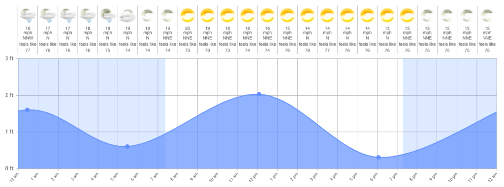
Fish like to feed when current is going through an area.
This is because the current acts like a conveyor belt at a sushi restaurant bringing them food.
To figure out the current, you would look at the slope of the darker blue area in the chart above from SmartFishingTides.com.
Since fishing is currently best during the twilight periods (more on this later) and dawn has stronger current flow (a steeper slope) than dusk, I would lean towards fishing dawn here if you just take into consideration current.
How To Plan A Fishing Trip: Wind
The wind affects fishing way more than I used to think it did.
For one, it affects current.
If you’re fishing near a pass or inlet and there’s an onshore wind combined with an incoming tide, expect the water levels to be higher than what the tide charts are saying.
Also, if the wind changes direction and there’s an offshore wind combined with an outgoing tide, then expect the current to be much stronger to be predicted.
In addition to affecting current and tides, wind also affects water temperature.
Wind will cool down water and bring extra oxygen into it, which is what you want in the summer and what you want to avoid in the winter.
So fishing windblown shorelines in the summer and wind-protected shorelines in the winter is usually a good strategy.
Trends: The Key To Planning A Successful Fishing Trip
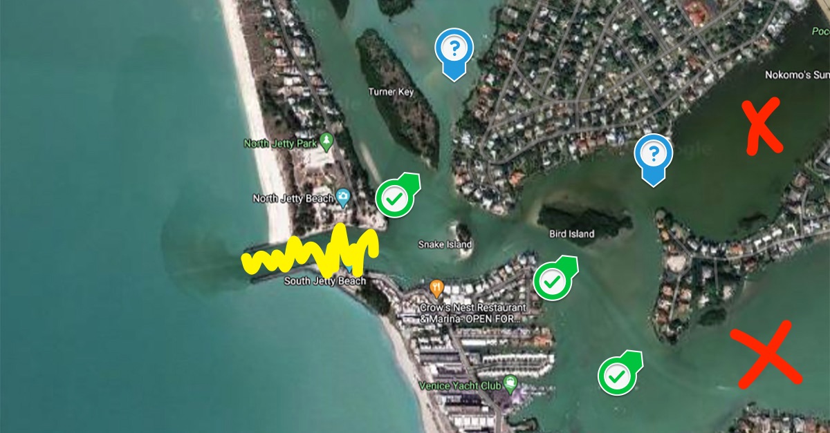
If I told you where Luke’s favorite spot to catch redfish is, it likely wouldn’t do you any good.
Here’s why: you need to know trends to find good spots.
What if Luke’s favorite redfish spot is only good in summer, but you go in winter?
Or what if it’s only good at high tide, but you go at low tide?
The trends are how fish are likely to behave under certain conditions and knowing them is the key to finding good spots and catching fish.
It’s currently late summer (at least the temperature makes it feel like summer), so here are the current trends:
- Fish are feeding at twilight periods
- They’re looking for cooler water
- They’re in and around passes and inlets
- They’re feeding around points
Knowing these trends, we can choose to go during twilight hours when there’s a strong current and find spots that meet the criteria from the trends.
Usually, Luke likes to pick about five different spots that are likely to be productive and then fish them.
Having a handful of spots picked out helps you have options in case someone (or a dolphin) is in your spot, or one or two of the spots just don’t seem to hold fish.
What Types Of Spots To Avoid
Here’s a scenario that happens a lot: someone is on their way to a spot, but then they see birds diving in the middle of the bay.
There must be bait around if the birds are diving, and if bait is around, then there’s likely predator fish around, so they go fish it.
But the problem with this way of thinking is that snook, redfish, trout, and flounder are structure-oriented fish.
If the middle of the bay is flat sand or mud, then it’s highly unlikely you’ll catch these fish out there.
So Luke recommends avoiding areas without any structure, no matter how enticing they might appear, if your goal is to catch snook, redfish, trout, or flounder.
Our Favorite Tool To Plan A Fishing Trip
SmartFishingTides.com makes it easy to plan your fishing trip because everything you need is in one place:
- Tide chart
- Weather forecast
- Google satellite maps (that has the street view and [and now water view!] so you can see exactly where you want to go)
- Sonar maps
We’ve even added in the Strike Score, which takes into account variables like wind, weather, time of day, barometric pressure, and more to give you an overview of when fish are most likely to be feeding.
The Easiest Way To Learn The Trends
Trends change throughout the year.
In this episode, we outlined a great gameplan for right now, but in a month or two, when the weather starts to cool off, everything we showed you today won’t work.
You could (and should) learn the trends yourself, but if you want a shortcut, then join us in the Insider Club.
Every Friday, in ten minutes or less, Luke creates a video talking about the current trends so you can catch fish during the coming weekend.
You’ll learn what’s working and what’s not so you can maximize your time out on the water.
As an Insider, you’ll also get access to:
- Spot dissections — similar to how Luke dissected this spot today
- Insider Reports where we show you exactly where we fished on a map, why we went there, and how it went
- Our 16,000 member community where people are sharing their fishing reports and asking and answering questions to become better anglers
- Discounts to everything in our online tackle store
Click here to join us in the Insider Club.
Conclusion
Planning your fishing trips more carefully is one of the best ways you can start catching more fish, no matter where you live.
Take into consideration the weather, wind, and tides, and combine that info with knowing the trends and you have a formula for success.
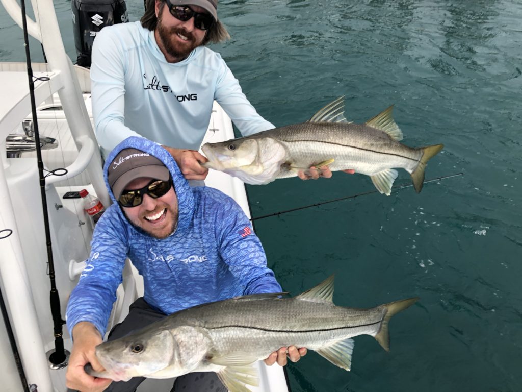
Luke recently used this exact strategy in this video to go to an area he’s never been to before and on his first cast hook a snook.
Do you have any questions about planning your fishing trips?
Let us know down in the comments.
And if you know someone who needs to plan their trips better, please TAG or SHARE this with them!
P.S. Want access to our best fishing spots and tips, plus discounts to our online tackle store? Click here to join us in the Insider Club!
Related articles:

I recently found that the satellite maps in the Windfinder app seem to have much more zoomable detail than others maps. Not sure who their sat data source is. Just click the maps button on Windfinder.
Great Video Luke! There were some awesome reminders in here 🙂
Guys, great video. Got a question on spot setup from a boat though. In the video you gave the example of approaching the point just west of Roberts’s Bay and southeast of the inlet (tide incoming, wind S-SE) from upwind so you could cast with the wind and retrieve with the current. Now the 2nd spot you identified was the southern tip of Turner Key which is north of the inlet. Now you have the current and wind flowing in the same direction. Where would you place your boat in this case and how would you fish that point?
I’d position up wind and cross-current so that I can cast with the wind and retrieve the lure without side wind friction while retrieving the lure across the current flow.
Thanks Luke!
I predominantly fish in and around Titusville, FL where there is not tidal flow and it is all wind driven. How when I go to the website, all it provides is just the satellite map because there is no tide station nearby. What would be the best way to apply this information in such a situation?
If you’re fishing in the north Indian River or in south Mosquito Lagoon, there isn’t enough current flow from the gravitational forces of the moon/sun to even worry about… it’s more about wind speed/direction.
I got a ton out of that video so thank you! I am having trouble when planning my own trips, factoring in the direction of the current flow. Yesterday, I set up a plan for a windy day based on having the wind at my back and the current flowing toward me. Unfortunately, I ended up at a spot where the wind and the current were both going in the same direction. I thought that because the tide was rising it would be headed in a certain direction but I misjudged. How can you be certain which way the current is flowing?
Sometimes you have to just evaluate when you get to a spot. As I’m going up to a spot, I always look at channel markers and/or buoys to see if any eddies of current are forming behind them (signifying the down-current direction). If fishing a grass flat, I look to see which way the blades are laying. If I don’t see any noticeable signs of current, then the current flow isn’t a big factor in positioning and I then just focus on the wind direction until I see an uptick in current.
What an area like Keaton Beach where the grass is out in the ocean and not inside the jetty?
I really enjoy your podcasts but this one is one of the best you guys have done. Thank you, keep up the great work!
Thanks Brett!
Thanks guys for the tutorial. I have been using this site since being a member and now that the pros have walked me thru the site, everything is a little bit more clear. I am amazed at the amount of info that can be had at this site.
I also just want to thank you, for all the hard work and heart that you put into getting this valuable info out to all of us that feel the need to hear our drag scream!
Thanks so much for making time to leave this nice commend Don!
What about water temperature?
We don’t bother worrying about absolute temperatures because the most important aspect is relative temps (vs. past few days and vs. nearby areas). Here’s a lesson on that: https://saltstrongdev.wpengine.com/articles/water-temperature-inshore-fishing/
I certainly agree with the relative trend factor, but, unless I am missing something (naw!), Ihave to find temp info on another site in order to track the trend.
On further thought, I guess that the whole temperature thing has a lot more impact here in North Carolina than it does further south. Even the availibility of some species begins and ends calendar-wise depending on both absolute temperature and trends up or down. The Smart Tides feature, as fabulous as it is, could benefit many of us by the addition of that information.
Do you include the moon phase in your planning? I’ve found full moons in the Jacksonville area kill the inshore bite for a few days
Great question, Stew. We didn’t cover moon phase on this pre-trip planning because this entire exercise was assuming we already had a precise day we were fishing the following day (which would mean the moon phase is mostly irrelevant since we have to make the best out of what the moon and mother nature gives us). But YES, we absolutely look at the moon phases if we were looking a month out to pick an ideal day.